
Typhoon hit central Philippines on Thursday 23rd December 2021.
In response to:
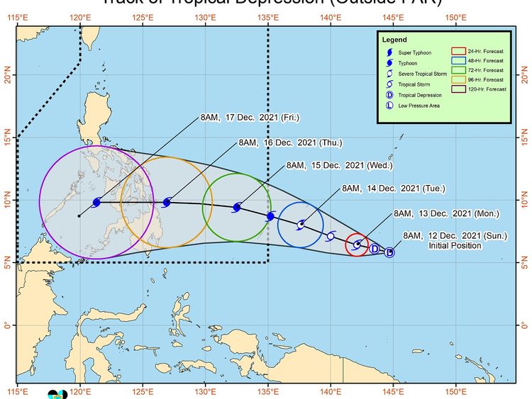
“The low pressure area outside the Philippine area of responsibility southeast of Palau has developed into a tropical depression,” Pagasa said in an advisory at 11 am Sunday.
December is typically a typhoon season in the southeast Asian country.
“Due to favorable environmental conditions, the tropical cyclone will likely continue to intensify and may reach typhoon category by Tuesday evening or Wednesday early morning,” Pagasa further said.
Weathermen said the tropical depression was spotted 2,095 kilometers east of Mindana as of 8am Sunday.
It currently packs maximum sustained winds of 45 km/h near the center and gustiness of up to 55 kph.
“Current track and intensity forecast shows that there is a moderate to high likelihood that Tropical Cyclone Wind Signal (TCWS) will be hoisted for the provinces of Visayas and Mindanao. The highest possible wind signal that may be hoisted for this tropical cyclone is TCWS #4,” Pagasa said.
Moving west
The weather bureau said the tropical depression is expected to move generally west-northwest over the next three days and may enter PAR on Tuesday.
The tropical cyclone will be named “Odette”, once it goes inside PAR.
Worryingly my home is directly in the path of this typhoon, thankfully my neighbours have rallied around and moved all things inside my home to high positions in case of flooding again.
Very frustrating that I'm still not able to return to check for myself, fingers crossed the sea/rain and wind will not do much damage locally.
Comments (6)
• OVERVIEW: According to the Philippine Atmospheric Geophysical and Astronomical Services Administration (PAGASA), Tropical Cyclone (TC)
RAI (Odette) has intensified into a TYPHOON as of 0700 HRS UTC +7 of 15 Dec. TC RAI (Odette) further intensified while moving westnorthwestward at 25 km/h over the Philippine Sea.
• INTENSITY: Maximum sustained winds of 130 km/h near the centre ang gustiness of up to 160 km/h, and central pressure of 970 hPa. Strong winds or higher extend outwards up to 400 km from the centre.
• FORECAST
1.Movement: forecasted to move west-northwestward until this evening or tomorrow morning then move westwards after. On the forecast track, the centre of the tropical cyclone is expected to make landfall in the vicinity of Caraga or Eastern Visayas tomorrow (16 Dec) afternoon or evening. It is then forecast to move generally westward and cross several provinces in Central and Western Visayas, emerge in Sulu Sea by 17 Dec and cross Northern Palawan before emerging in the West Philippine Sea.
2.Intensity: further intensification is expected today through tomorrow (16 Dec) as the typhoon crosses the Philippine Sea and may reach a peak intensity of 155 km/h prior to making landfall tomorrow afternoon. This tropical cyclone may see some slight weakening as it crosses the Visayas and Palawan, but it is forecast to remain within the typhoon category. Reintensification is likely once TC RAI (Odette) emerges over the West Philippine Sea.
The British Red Cross is giving aid where they can, but the most important right now is getting water to the southern parts still cut off with blocked roads from landslides etc.
Cebu and Visayas regions of The Philippines will not be enjoying a very happy Christmas this year.
And yet still some think bellyaching about some vaccine is more important