Here is a list of Travel Blogs. A Blog is a journal you may enter about your life, thoughts, interesting experiences, or lessons you've learned. Post an opinion, impart words of wisdom, or talk about something interesting in your day. Update your blog on a regular basis, or just whenever you have something to say. Creating a blog is a good way to share something of yourself with others. Reading blogs is a good way to learn more about others. Click here to post a blog.

Tadoussac, QC. Trip
Going to the Youth Hostel !
Might Use the Prospector Tent !
Adventures with Pauly !

where are you going ?
This summer where you will travel and spend a wonderful time
I will be in Turkey to enjoy this atmosphere
There is a very beautiful nature, historic sites and many beaches
You can share your experiences and tips to go to the sites you enjoyed
I wanted to share these ideas with you
I wish you very enjoyable times

The Hollow Whistle of Iron Horses Part V
Rattlesnake Lake is not the home of poisonous rattlers, and, in fact, no poisonous snakes inhabit Washington State. Legend has it that Rattlesnake Ridge and the subsequent lake were named when a railway worker heard the rustle of the wind blowing the camas seed pods, sounding identical to a large rattlesnake.
As dusk blankets the park, Rattlesnake Lake's unmarred surface gleams a muted blue-green in the fading light. Children with dogs throw sticks on the sandy shoreline, parents in close proximity with watchful eyes. Due to the lack of directional signage on the rail trail, locals are more than helpful for directions and information. Picking up the Snoqualmie Valley trail, it takes you through five miles of more spectacular scenery and directly over the raging Snoqualmie River into North Bend. Again, signage would be helpful to indicate where to turn to the main street of North Bend.
Thirty miles and ten hours later, the North Bend Motel is a short 3-block drive
from the parking lot near Compass Outdoor Adventures. On average, the trail should only take about 4-5 hours to ride, but photography buffs may find themselves spending an inordinate amount of time recording the many distractions along the trail. The tunnel opens May 1st, however due to snow build-up in front of the huge doors, a plow was brought in to displace the snow and it officially opened May 2nd.
Lights, a jacket, even on the hottest days, water (there is no water on the trail), reflective clothing are all highly recommended, and most of all, be prepared to have the ride of your life!
......
copyrighted.
The Hollow Whistle of Iron Horses Part IV
Campsites for backpackers and bikers can be found at Carter Creek, 8.3 miles from the tunnel (just past the Bandera sign) and Alice Creek, an additional 3 miles down the trail. McClellan Butte trail shares the signpost with Alice Creek, dropping sharply off the side of the rail trail to the north.
McClellan Butte is named after George B. McClellan, a Civil War general and surveyor during the mid 19th century. In search of the most viable mountain pass for the proposed transcontinental railroad system, McClellan surveyed the Cascades Mountains in 1853. Ignoring nearby Snoqualmie Pass, which would eventually be the actual mountain pass used by the Pacific Railroad, McClellan's efforts did not go unnoticed and "McClellan Butte" was named in his honour.
One of the most popular hiking and climbing destinations in the region, McClellan Butte, a distinct horn-shaped peak rising above South Fork Snoqualmie River Valley, offers a combination of easy hiking trail or a more difficult summit scramble for rock climbers.
Past the signpost marked Garcia and the subsequent gravel road thusly named, two young mountain bikers drop fearlessly off the perpendicular side of the trail into heavy bush and descending trees. Two worn paths indicate where this has been a favourite drop-off for youngsters needing a challenge.
The long curve of Mine Creek trestle at 22.5km (mile-14) offers more spectacular views and a heart-in-mouth peek over the edge as tires bump unevenly over concrete slabs, replacing former wood planks. Approximately 2km (one mile) west, the Change Creek and Hull Creek trestles span two more seemingly bottomless gorges along the precipitous rock face of Deception Crags.
Late afternoon, clouds descended, hiding prominent McClellan's Butte and greasing the sheer bluff of Deception Crags, a favourite spot for rock climbers. Frequently, climbers can be seen both directly above the trail, and across the valley, northward. Taking a rain jacket is highly recommended on a cloudy day, as it's more than likely to rain than not. Riding through clouds, over trestles traversing seemingly thin strips of rivers hundreds of feet below, swirling mist allays height fears.
Twin Creek hiking trail descends steeply 17 miles past the summit towards Twin Falls. Numerous waterfalls and creeks splash noisily down the mountainside disappearing deep beneath the rail trail. Rarely was a stream or creek on the hillside seen to exit directly below the trail. Rushing water can be heard far below, but it's noisy exit, invisible.
A mile further, "Ragnar" signage (pic) indicates where the storage yard and old depot was located. A large meadow is home now to piles of rusting metal, mounds of removed creosote soaked ties, and greyed wooden beams. Coasting past the dilapidating piles of railway history, Boetzke Creek trestle marks the final trestle on the almost 30km (18.5-mile) bike ride, and more spectacular views over the Yakima Valley and Snoqualmie River.
Cedar Butte and Boxley Creek indicates the 33.79km (21-Mile) mark, although there are few signs indicating milestones on the trail. One sign painted as 11.2-miles is the only indication you are halfway to your destination. Signage for visitors would be most helpful in gauging where you are, how far you've travelled and how much further you have to go.
Twin Falls signage, along with everything but Rattlesnake Lake, mark the entrance to the parking lot off the trail, unless one chooses to ride further towards Twin Falls. Again, no signage indicating Rattlesnake Lake is a little disconcerting when it's getting late and you don't want to be on the wrong trail as dusk descends. Weaving through unmarked forested trails, the overflow parking lot is a short jaunt from Rattlesnake Lake.
...continued...
The Hollow Whistle of Iron Horses Part III
Picnic tables gleam wetly from a recent rainfall, and lily-like wildflowers bloom abundantly along the trail edge. Steep drop-offs remind you of the 3,352M (11,000-foot) elevation at the tunnel, down to 440 feet in the valley. Iron Horse trail is an ideal trail for kids and adults alike, regardless of fitness level, due to its gradual grade. Twenty-two miles long from the tunnel to Rattlesnake Lake, it's an easy downhill ride from peak to valley.
From the nearest curve, two hikers with long walking sticks trudge up the gradual incline. As they grow closer, one sported a full head of gleaming white hair and bushy, snowy beard. Suspenders held up beige corduroy trousers and a camouflage work shirt completed his mountain man ensemble. His co-hiker is less noticeable, but no less prepared for the hike. (picture). Shortly behind them, five more women and men catch up to join them. Friendly, curious, knowledgeable and helpful, they imparted their wisdom of the trail and its nuances prior to entering the tunnel and being swallowed in its darkness.
Cruising on the gravel path, approximately 4.5 miles down, an aging snow shed still stands, the pungent scent of creosote permeating the air. Thick cables hold the beams in cement slabs against the mountainside. The Chicago, Milwaukee, St. Paul & Pacific railway built snow sheds at strategic places where avalanches were common.
Designed to protect the track from being blocked by avalanches, an avalanche would flow over the top of the roof of the snow shed, missing the tracks, preventing blockage, or worse, derailment. Looking up the steep mountainside above the snow shed, you can see a wide treeless section of hillside, an avalanche chute, a testimonial to their power and devastation. This part of the track was a prime location for a snow shed. Although there were many snow sheds along the railway, this one is the only one left standing, the others all being demolished in 1997-1998.
Cycling through varied terrain, from thick forests to open meadows, talus slopes (pic) and sheer rock face, the scenery is nothing less than spectacular with unparalleled views. Approximately 11km (7 miles) down the trail (remember, we are in the US), the rush of highway traffic from I-90 competes with the roar of water as Hansen Creek trestle spans the deep chasm. Thick, loose gravel on the trestle makes cycling a bit slow going and unwieldy. Gearing down makes it manageable, although there is plenty of width to dismount and walk across. At the first of the trestles, the noise and height is enough to frighten any confirmed acrophobe. Chain link fencing lines both sides of the trestles, but anyone with a fear of heights understands that fencing of any kind is irrelevant. The scenery across the valley is phenomenal; - looking down is optional.
Numerous hiking trails dissect the old railway line, the Annette Lake trail crossing a mere 6.75km (4.2 miles) from the tunnel and just before the snow shed. As with the rail trail, waterfalls, wildflowers and mountain vistas abound and hidden in their midst, the pristine Annette Lake is surrounded by Humpback Mountain and Silver and Albiel Peaks. Cycling is restricted to the rail trail. The hiking path crosses high above Humpback Creek, its deafening roar is muffled by distance and sheltering trees.
Past Hansen Creek trestle, an old sign announces Bandera with views to the north of Bandera Mountain and Granite Mountain. Low clouds shroud their peaks on this day, lending a mysterious air to the hidden peaks, fingers of mist swirling amongst the trees. The rush of traffic on I-90 is audible as it winds through the mountain pass, periodically visible amongst the dense forest. Burgundy, pale pink and white glacier lilies dot the trails at this elevation in spring, and yellow wood violets bloom haphazardly in mossy areas.
....continued....
The Hollow Whistle of Iron Horses Part II
Heading half a block further west, Compass Outdoor Adventures rents bikes and offers a shuttle to Snoqualmie Tunnel from a second storey retail space. A steep ramp behind an overhead garage door leads up to the office/store where you're greeted by one of their friendly staff. A yearling company, they offer corporate packages for team building, as well as children's summer camps, bike rentals and the shuttle. Driving from North Bend to Snoqualmie tunnel, the 20-minute drive through the pass affords visitors the opportunity to view parts of the trail from an alternative perspective.
Reaching the parking lot, snow lays in quickly melting mounds on the mountainside, and in the runoff ditches near the tunnel entrance, having been plowed away from the immense doors only two days prior.
Dropped off, there is only one way back to town, and that's through the spooky tunnel that evokes imaginings of the worst kind, and over trestles to challenge any fear of heights. Alone, pedalling slowly through puddles of water from still melting snow, a sudden blast of frigid air displaces the humid heat, chilling bones and raising hair on arms and back of neck. There is nothing but the mountain around you, and the curve in the path before you. Where are those icy fingers of air coming from?
Rounding the corner, massive wooden doors stand open to blackness so thick, it seems to seep out of Snoqualmie Tunnel. Despite the heat of the day, the tunnel, 2.3 miles of blackness so dense it swallows photons, the only light visible is the exit, a tiny pinpoint in the distance. Like a beast lurking 457 M (1500 feet) under the surface of the lower slopes of Mt Catherine in the Cascade Mountains, it funnels warm air into its belly from the west, exhaling it's raw breath in frigid gusts to the east.
Like a runaway train, imaginations careen wildly as the tunnel blindfolds its inhabitants in sightless dark. Auditory senses acutely magnify drips from rounded ceilings and your own breathing, (that was yours, right?) echoing with tires crunching on packed dirt and gravel. One can almost hear the shouts of the men in the 3,624 M
(11,890-foot) length, the longest in the railroad's system in 1908. Detonating 340 tons of dynamite, blowing it up 100 rounds at a time, approximately 2,500 “tunnel stiffs" removed 180,000 cubic yards of rock, finally completing it in August 1914. Built to by-pass avalanche prone areas in Snoqualmie Pass, the first train entered the tunnel in January 1915, keeping Seattle and the Midwest connected.
Donning a jacket against the chilly dampness, a 505 LED lumens attached to the right front fork of a bicycle barely pierces the deep caverns. Pinpricks of light and reverberating footsteps are the only indication of other tunnel inhabitants, impossible to gauge how far away or near until almost toe to toe. Alone, the tunnel has an eery silence, initiating a faster pace through its creepy sightlessness.
Nearing the west end of the tunnel, still immersed in inky darkness, sounds of ceiling drips are masked by the roar of rushing water, seemingly overhead. Emerging into light and warmth, you get a definite sense of the weight of mountain you've been cycling under and exactly how much earth is overhead. To your right, a stream crashes its way over rocks and deadfall, carving a steep path to the distant valley below.
Heavily laden grey clouds swirl around towering evergreens, veiling surrounding mountain peaks. The Iron Horse trail, a gradual 2.2% grade, winds its way through thick forests, disappearing into the distance. Ribbons of silvery streams reflect the cloudy conditions, peeking through far-off valleys, hundreds of feet below. Hues of near-by summits fade from forest green to paler shades of blue on the horizon.
...continued....
The Hollow Whistle of Iron Horses
North Bend, Washington is approximately a 2.5 hour drive from the Abbotsford, Huntingdon border on I-5 and I-90. The scenic route, Hwy 9 to Snohomish, east on SR (State Route) #2 to Monroe, turn right (south) on Wa-203 to Duvall and Wa-202 to Snoqualmie and North Bend, winds through some of the Pacific Northwest's most spectacular scenery. Hwy 9 is a secondary two-lane highway, dotted with lush green farms and dense forests, broken with numerous lakes along the way, including Lake Whatcom, Big Lake, Clear Lake and Lake McMurray. Be sure to stop by the acreage advertising bird houses, with ancient vintage cars in all kinds of disrepair parked haphazardly on the lawn.
A fill-up at the old-fashioned Lake McMurray Gas Station or a stop for snacks will introduce you to Yumi, the owner. Yumi, originally from Japan, settled in Lake McMurray 36 years ago after purchasing the store/gas station. Her initial immigration into the US had her settling in California, steadily moving northward in three different cities. The Pacific Northwest's similarity to Japan drew her to Lake McMurray, eventually purchasing the properties on both sides of the gas station . Her passion for flowers is evident year round, with flowers blooming inside and outside. Through the back door of her store, an abundant garden flourishes in the rear where several pots of beautiful orchids are carefully placed for fresh air and sunlight.
Her home next door is a vintage 1910 model that she spent 8 years renovating and restoring. Owning all three properties on the curve of the road ensures that no one will build around her, leaving her an unimpeded overlook of the lake.
Further east and south, both Monroe and Duvall are small cities teeming with history and well worth a visit on their own, each one proudly displaying restored historic storefronts housing modern businesses. Southeast, past Falls City (be sure to take an inner tube for floating under the bridge in the summer), Snoqualmie Falls, the hydroelectric plant, warrants a stop to view the impressive dynamism of the falls as they crash 81.6M (268 feet) into the river below.
After observing the falls, a short drive to the City of Snoqualmie greets visitors
with the Northwest Railway Museum, the massive ancient engines and cars sidelined on unused tracks at the city's entrance. North Bend Motel offers clean rooms with a fridge and microwave. They do not supply coffee pots or coffee, but Twede's Cafe, boasting a traditional 1950's decor about three blocks west, serves a "damn fine coffee" in large mugs with bottomless refills. For $10.00, buying a pound of coffee beans is well worth it, it's tagline a testament to its smooth flavour.
Twede's Cafe's breakfasts are large and delicious. Their Denver omelette is stuffed full of peppers, onions, cheese and ham, and fills an entire platter. They gladly substitute a side of four pieces of bacon for a lack of hash browns and potatoes without up-charging. Between their "damn fine coffee" and delicious omelette and bacon, you're more than fuelled for the day.
....continued.....
This is the first blog of ? of a travel article I wrote on cycling from the top of Snoqualmie Mountain a couple of years ago. It'll be two years next week, and I'm dying to go back there and experience it again. I will post the next part tomorrow.
That sinking feeling.
Because I can, that's why.

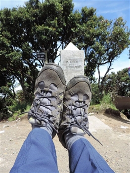
story from 2.958 m.dpl to Gede Mountain
sometime I enjoy do do it.. and, im lucky that my friend in the office offering to joined them on this trip.
.. i know, that i'am not young anymore...
but.. with all my confidence, i joined..
... tired,.. of cource yes.. , imagine that i should pickup my carrier by myself with no porter.. the bag size is same bigger with me :
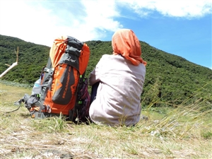
But after you get the top of the mputain, .. you well meet paradise in the front of you.. so.. your tiring will payed full
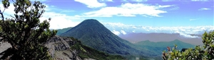
..so.. let's go to enjoy the natural sceenery...

A Blog is a journal you may enter about your life, your thoughts, interesting experiences, or lessons you have learned. It's your own page on Connecting Singles that you can update on a regular basis, or just whenever you have something to say. You can write about an opinion, impart words of wisdom, or talk about something interesting in your day. Creating a blog is a good way to share something of yourself with Connecting Singles members. Reading blogs is a good way to learn more about members you have met here. Please be sure to read the blog rules before posting.
Would YOU like to post a blog on Connecting Singles? Have you written blogs that you'd like to share with other members? Posting your blogs shows your skill and creativity and helps members get to know you better. Your blog will appear on the Connecting Singles Blogs page and also in a link on your profile page. Click here to post a blog »